

FBI Network Investigative Technique Case – Motions and Briefs
September 3, 2019
Sample Order for EMR Site Inspection
November 27, 2019Determining Location of a Mobile Phone – Is it Junk Science?
I often work on cases involving Location Based Services and Global Positioning, I worked a case where the FBI provided coverage maps for cellular coverage that was very misleading and could sway a jury if not fully explained!
The FBI expert provided Call Data Records as the basis of a cellular coverage map. Call Data Records are billing records, but are often used to show the location of a subjects phone based on cellular site where a call was first placed. Creating coverage maps from the longitude, latitude, azimuth, beam width and coverage length is a gross misrepresentation of evidence. The only data that can be used to show real coverage is created by an RF Engineer for the mobile carrier and is known as a Sector Map and sometimes NELOS records. The problem with the mobile operators providing Sector Maps is that they show ‘real’ mobile coverage and often do not match the FCC Quarterly filings or the advertised coverage that is shown to consumers. The mobile network and virtual operators rarely provide law enforcement with true coverage maps. Instead they simply swap the true coverage with the planned or engineered coverage area. This is a huge problem and law enforcement has been relying on this data and went as far as creating their own classes, schools and certifications based on this junk science. What is even more disturbing is the photos online of the Mobile Network Operator legal compliance staff carrying guns at work all wearing khaki’s and holding law enforcement awards as if they were sworn officers.
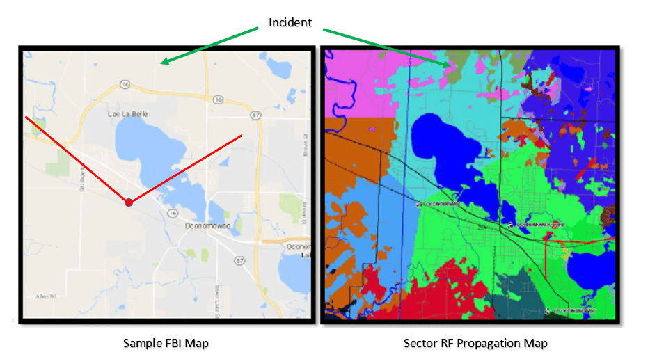
Just because the engineering team decided to construct a mobile tower and point it in a specific direction does not mean it behaves the way they intended. This is obvious based on the radio frequency propagation map provided to me by US Cellular below. You can see the light blue shaded area is not a perfect cone or triangle despite the claims made by law enforcement.
Determining Location of a Mobile Phone
The courts have had mixed opinions regarding these misrepresentations. I am going to quote from the order in US v Antonio Evans 10 CR 747-3 “Special Agent Raschke may not testify concerning the theory of granulization, which the court finds to be unreliable. In addition, the estimated coverage areas contained in summary exhibit 6 must be removed before the court will admit this exhibit. Evans’s motion for disclosure of expert evidence under Rule 16 (dkt. #122) is denied as moot.”
Whether it is Google or a Mobile Network Operator, having a cell phone forensic expert to guide you through the process to obtain the right data is critical when defending a client.
So you’r asking if we have tested this theory? Yes
Have we tested this in court? Yes
There are many other factors such as environmental, banding (3g v 2g v 5g) but reports same tower ID, trunking, NELOS and weather that can affect coverage as well. This article was written to spark a conversation and is not a full accounting of the wireless ecosystem.